Walking the Voie Nive Bidassoa: Connecting Saint-Jean-Pied-de-Port to Irún
Why the Voie Nive Bidassoa?
After walking the Via Podiensis in September and October 2023, we were looking for a way to connect from Saint-Jean-Pied-de-Port (SJPdP) to a Spanish airport (Irún, Spain) to fly and meet up with a friend in A Coruña, Spain to walk the Camino Ingles. On our Camino Frances in 2021, we enjoyed walking through the Basque country of Spain and wanted to hike through another Basque region in France.
In online Camino forums, people are frequently looking for connections between SJPdP and transportation hubs in Northeast Spain and Southwest France, so we decided to detail our experiences here.
Last, as a French Wine Scholar, I was interested in walking through the AOC Irouléguy, a tiny and historic wine region in the southwest corner of France.
Our Thru-Hiking Style
We prefer a private room with an ensuite or adjacent bathroom for long hikes. We book our accommodations ourselves and in advance. We typically book a three-star hostel, inn, or gîte (Europe uses a 5-star rating system).
We eat meals with food provisioned from our accommodations, grocery stores, restaurants, and markets along the route. We like to eat out several times weekly, selecting small restaurants with food typical of a region. We also enjoy a glass of wine or a beer about once daily. In France, many accommodations offer a demi-pension, including dinner, lodging, and breakfast, for one price.
We carry our kits (15 - 18 lbs each, depending upon daily water needs) and don’t have them sent ahead with a luggage service. We limit our checked luggage to a robust box, which includes our hiking poles, pocket knife, and Leatherman knife.
We like to walk 22 to 28 km (13 to 17 miles) per day. We plan about one rest day a week.
We average €150 per day on this hike for a couple ($80 per person per day). In the fall of 2023, the exchange rate was $1.08 for €1.00. When we list prices for lodging, meals, tours, etc., it is the total for two people.
Including prices, our blog provides valuable information for readers, helping you budget and plan your trips more effectively. It adds transparency, aiding decision-making and allowing readers to assess the affordability of various destinations, accommodations, and activities.
For health insurance, we use expatriate health insurance year-round, which covers us globally and throughout the United States.
For mobile phone coverage and data, we use Google FI. Occasionally, we supplement Google FI with a local SIM card from a cell phone shop.
Our website is ad-free. We may use Amazon affiliate links for some recommendations. We make a small affiliate commission whenever you use these links - at no additional cost to you. Thanks for supporting our blog!
What is the Voie Nive Bidassoa?
The Voie Nive Bidassoa is a hiking route that connects Saint-Jean-Pied-de-Port to Irún, Spain. It is primarily known as a way to connect the Via Podiensis to the Camino Norte. The Voie Nive Bidassoa also connects Saint-Jean-Pied-de-Port to the San Sebastián Airport (EAS) in Irún, Spain.
The route passes through the foothills of the Pyrenees and is approximately 80 kilometers (50 miles) from Saint-Jean-Pied-de-Port to Irún, Spain. While not flat, it is a less mountainous path to than the GR10. The route passes through the villages of Bidarray, Espelette, Ascain, and Hendaye before you cross the river and enter Spain and the city of Irún.
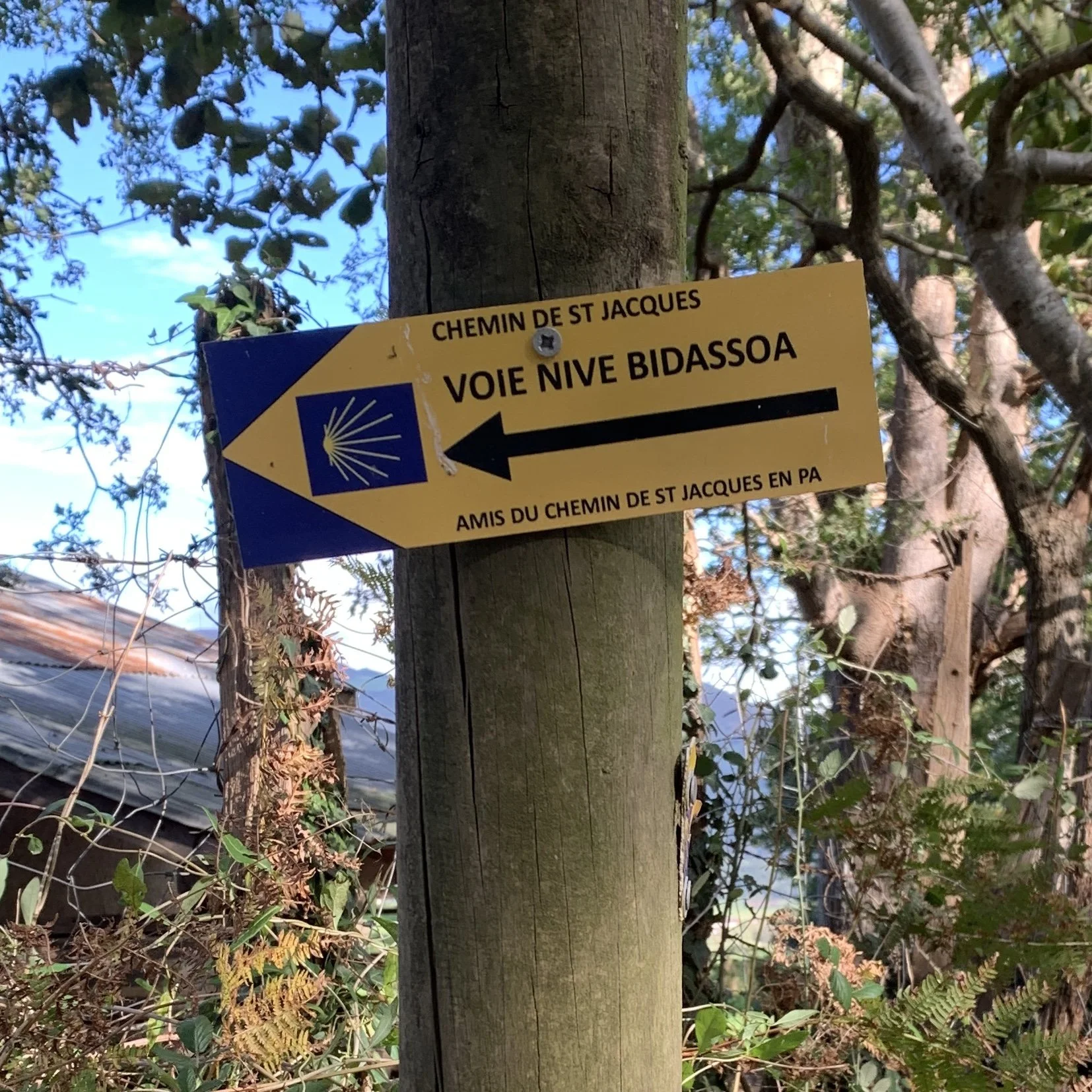
This foothill and valley route is signposted with yellow and blue signposts with blue shells and yellow arrows. The route is shared somewhat by the GR8. The route labeling can get a little confusing at times, with multiple signs for the multitude of paths in this region. We highly recommend using GPX tracks to navigate this route to reduce the number of wrong turns.
How Technical is the Voie Nive Bidassoa?
The track consists of asphalt, two-track gravel roads, and dirt single paths. Heavy leather hiking boots would be overkill for this route. Trail running shoes like the Hoka Speedgoat, Altra Olympus, or Brooks Cascadia are sufficient.
Planning Resources for the Voie Nive Bidassoa
We used maps and this Via Podiensis guidebook below (released in 2022) to plan our Le Puy trek and to take the Voie Nive Bidassoa.
Guidebook: Camino de Santiago - Via Podiensis: Le Puy to the Pyrenees on the GR65

In addition to the GPS coordinates available in this book, we also found these GPX tracks to be helpful.
As far as guidebooks specifically for this route, one guidebook in Dutch is available through the Flemish Compostela Society on the Via Nive Bidassoa.
In our experience, you won’t get a holistic overview of the Via Nive Bidassoa at the Saint-Jean-Pied-de-Port Pilgrim Office. Volunteers with varying or little knowledge of the route work in the office. The office's primary focus is to help new pilgrims on the Camino Frances. A list of lodging is available at the office, which may or may not be current.
Like most Camino guidebooks, this book does not tell much about the food, wine, and culture of the region's people. Since Camino guidebooks typically focus on getting one from point A to point B efficiently (and cheaply), here are a couple of other resources for learning more in-depth about the region.
Wine Guide: Wines of Southwest France
Written by a scientist with a passion for facts and plain language on food and wine (aka free of bullshit insider jargon), you’ll get a great understanding of wines of the entire region of Southwest France you’d walk through on the Via Podiensis.

And here’s a short Rick Steve’s primer on the culture and scenery of the region:
What Is There to Enjoy in this Region?
This route is known to Camino enthusiasts as a connector. Most Camino walkers are looking to get from Saint-Jean-Pied-de-Port to the Camino Norte quickly, safely, and cheaply.
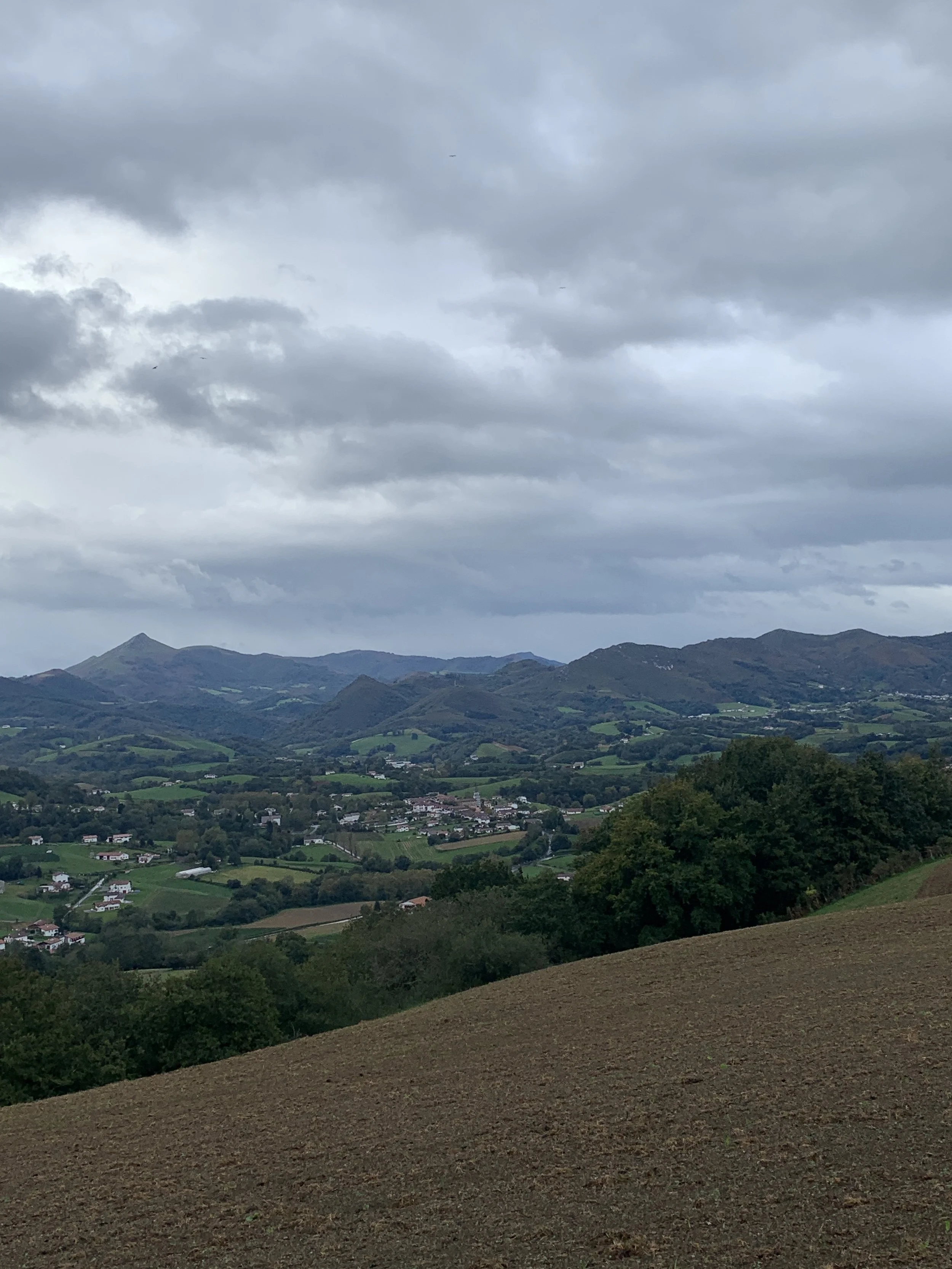
What’s overlooked in the (English) guidebooks is that the landscapes are dramatic. For four days, one hike in the foothills at the base of the Pyrenees. We enjoyed the landscape of these four days more than the previous week’s walking into Saint-Jean-Pied-de-Port.
The people are warm and friendly. You’ll be walking by many tranquil farms on this route. In mid-October, we saw beef and dairy cattle and various breeds of sheep. As you get closer to the coast, you’ll see more fishing boats.
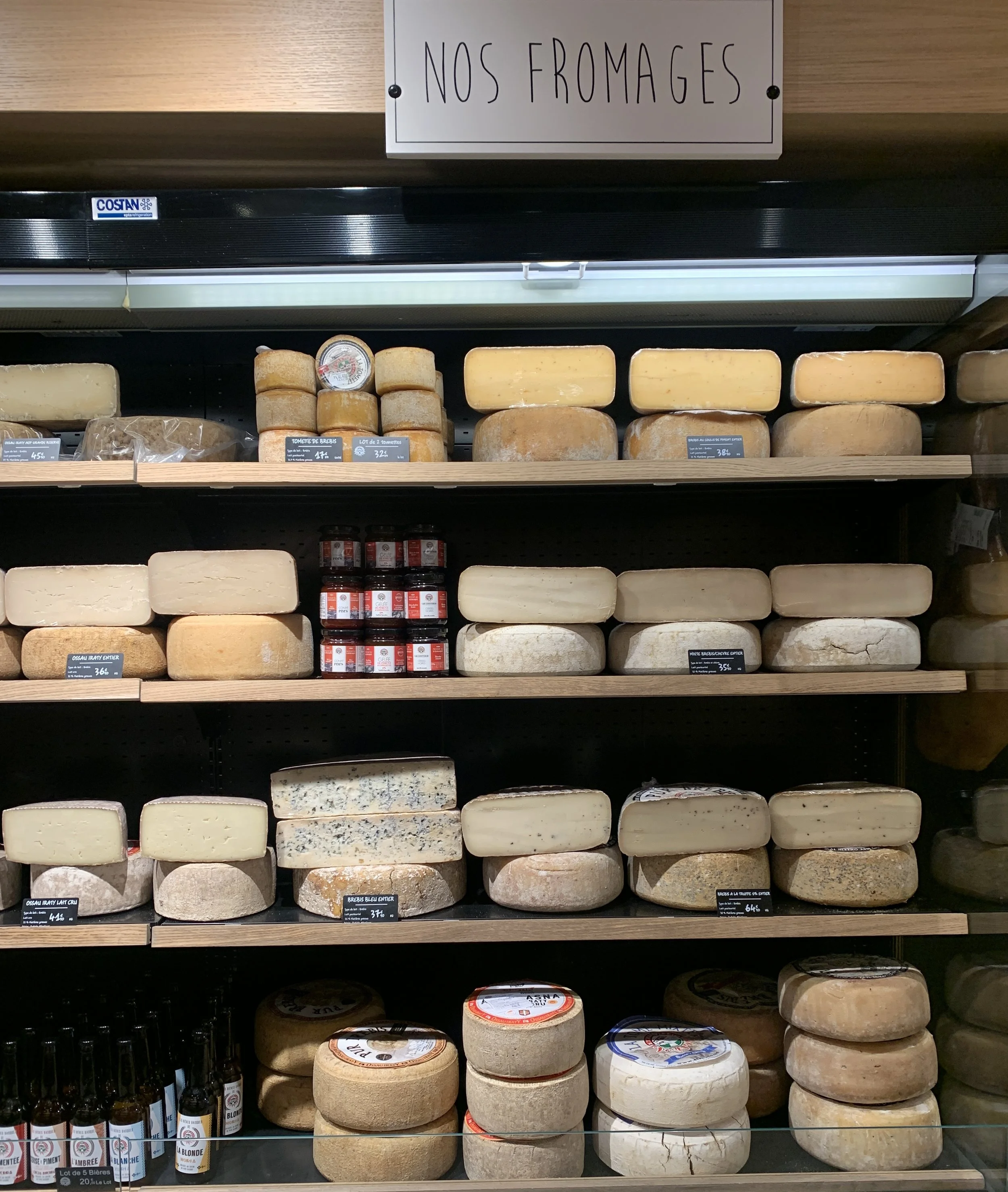
The food is rustic and delicious, with both simple and gourmet restaurants in abundance in larger villages. The cuisine features various stews, cheeses, sausage, peppers, wine, and famous jambon.
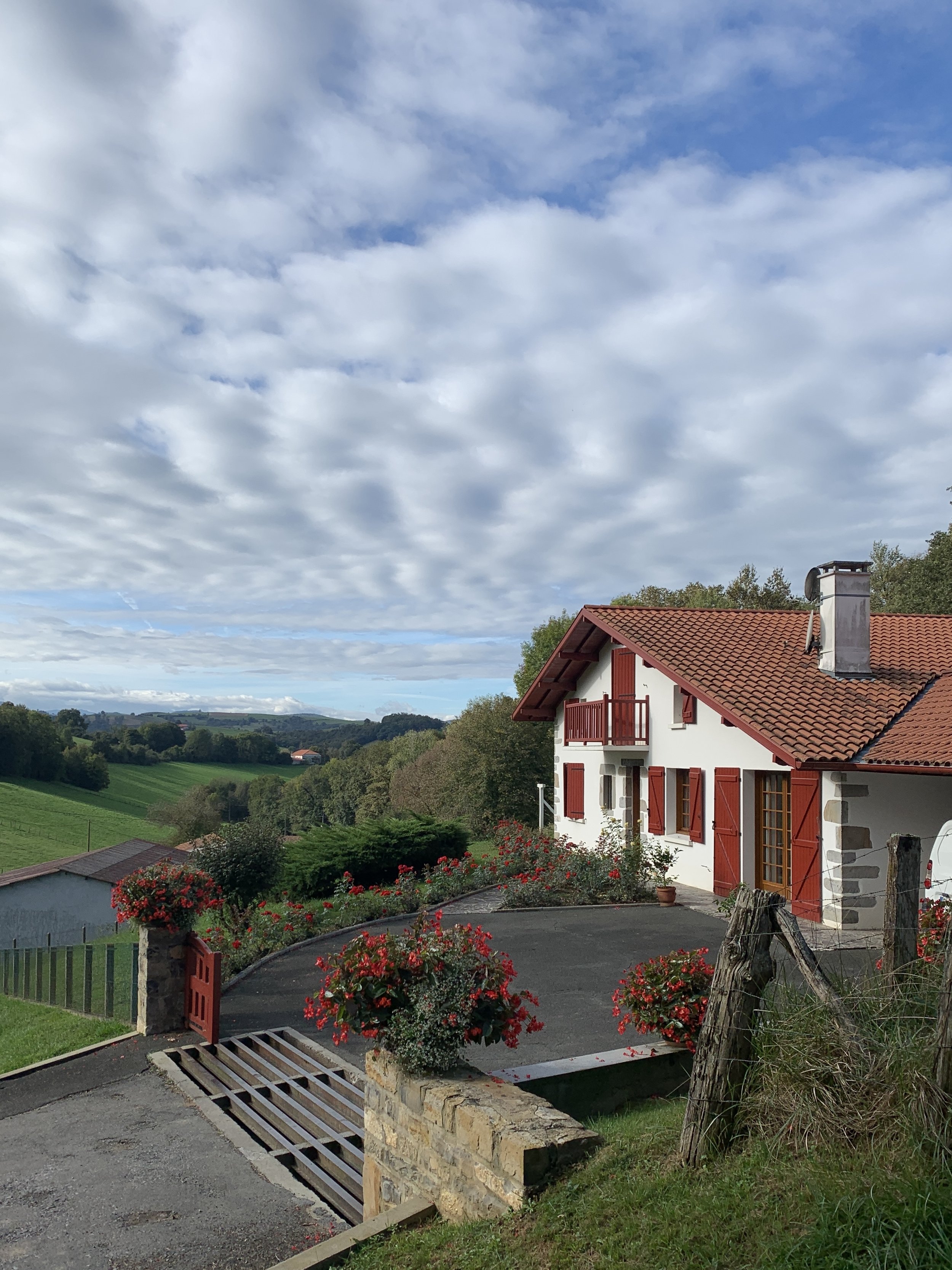
The architecture and color of the homes is unique to this region. The colors of the houses are typically in keeping with the colors of the Basque flag—red, white, and green.
Who would not like hiking through this region?
For travelers who prefer international processed food like spaghetti and canned tuna, this may not be the right route. Its honestly difficult to find these types of food in the region. If your budget allows for only cheap, basic eats, bring provisions from Saint-Jean-Pied-de-Port. Dining out in this region can be inexpensive; many restaurants offer hearty and generous menu-of-the-day deals under €17.
The region might be difficult for vegetarians and vegans, but pescatarians will have plenty of options. The cuisine is meat, fish, and cheese-heavy since the occupation of many in the region is farming, cheese-making, and fishing.
In October, we met only one other couple hiking in our four days. Hikers looking for the social experience typical of the Camino Frances or bar nightlife might find the route too quiet.
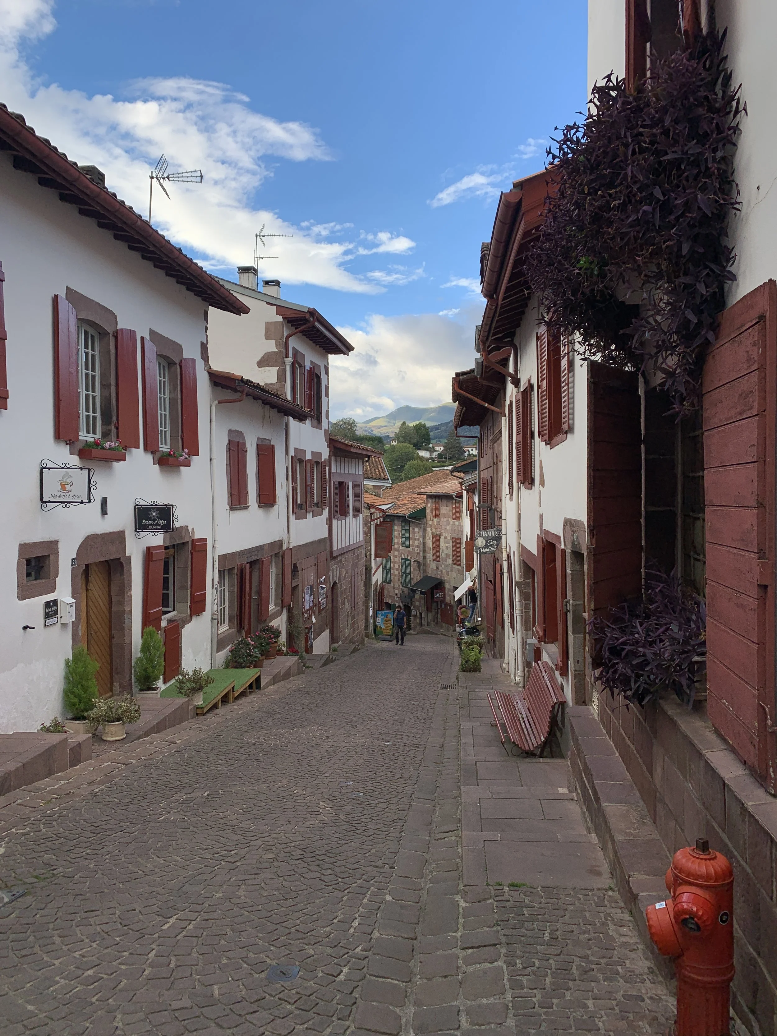
Saint-Jean-Pied-de-Port, France to Bidarray, France
On 18 October 2023, we left SJPdP around 9 am. The town was tranquil. There was a noted absence of hikers and tourists as most hikers leave early to cross the Pyrenees and make it to Roncesvalles, Spain, by late afternoon, and the day-tripping tourists had not arrived yet. Shopkeepers were picking up debris from last night’s storm (high winds and some rain) and setting up for the day.
We found the signage poor in SJPdP regarding the Voie Nive Bidassoa poor, so we relied on GPS to navigate out of town.
As we gained elevation out of town, it became quite windy, with wind gusts over 50 mph (80 kph). We saw several “widowmaker” branches fall from trees. Once the winds died down, we walked quickly to the protected valley below, where there was little wind. There, we passed a small herd of Betizu cattle, a “semi-feral” rare cattle breed unique to the region.
Midday, we had lunch in the park of Irouléguy, sourced from leftovers from our apartment in SJPdP. We were able to top up our water at the nearby new bathroom facilities in Irouléguy. These facilities are tucked behind Agerria, a foie gras producer. There’s another water stop and picnic table in town in front of Église Ste Marie.


As we resumed hiking, we could see the vineyards of Irouléguy AOC in the hills. Grapes have been growing in this region since Roman times. Today, mostly red wine is produced.
In the valleys, there were various farms, including horses and trout. We saw several sheep that had just given birth to lambs that morning and in the previous 48 hours. The only wildlife we observed was a pheasant.
The landscapes were dramatic—the Pyrenees were towering above us and increasing in size as we progressed on the trail during the day.
We arrived at Hotel Restaurant Noblia around 17:00 and promptly enjoyed a beer on their terrace. Dinner was at the hotel and served at 19:30. We had the menu of the day - a locally farmed trout with egg, sliced tomato, cheese, fries, lettuce salad dressing, and homemade creme brulee. Breakfast was simple and traditional—orange juice, coffee, croissant, bread and jam. The chef made us each a sandwich of jambon pays for the next day.
Distance: 25 km
Lodging: €158.38, which included the recently updated room, two beers, dinner, breakfast, and two sandwiches for lunch on the 19th.
Bidarray, France to Espelette, France
On 19 October 2023, we left Bidarray around 9:00. We timed our departure to avoid the early morning and forecasted late afternoon rains and wind from Storm Babet.
It was a fairly easy trek, with an attractive route near the river Nive. We then climbed a big hill and could see the Atlantic Ocean from there.
Our timing was great; we avoided almost all of the rain and made it to Espelette at 13:30. We checked into the Hotel Restaurant Chilhar, which had just finished lunch service.
Finding food was no problem, the town is obviously a foodie paradise, chock full of stores selling jambon, fois gras, pate, peppers, wine, cheese, and numerous other regional delicacies. We stopped into one of the boutiques and purchased a wine—Mignaberry Rouge (Irouléguy)—to go with our jambon pays sandwich. We also picked up some provisions for the next day, which included saucisson with mushrooms and Ossau Iraly cheese aged 6 months.
Our hotel was not open for dinner, so we went instead to Hotel Restaurant Euzkadi, a few blocks away. The restaurant is over 150 years old and is currently being run by the 7th generation. We each had a gin and tonic and the starter, Garbure (a spicy vegetable stew with cabbage, carrots, potatoes, leek, pepper, ham, and white beans). For the main course, Darren had Axoa d’Espelette (veal, green & red peppers, jambon, onions, garlic, white wine, and pepper) and I had Pulpo (octopus) with chorizo. The dessert was one slice of Basque cake and rice pudding.
Distance: 17 km
Lodging: €112.58. Meals: €73.00. Other: €34.63 wine, cheese, and saucisson
Espelette, France to Ascain, France
On 20 October 2023, we left Espelette around 8:30 after a breakfast of chocolate and plain croissants, orange juice, sheep yogurt, jam, bread, and a fresh fruit salad.
We needed a big breakfast as this is considered the most difficult portion of the Voie Nive Bidassoa, as there are two large hills to climb. Technically, it is not too challenging, with all the surfaces being roadway and rough gravel.
We stopped to pick up two beef sandwiches and a small slice of Basque cake at a bakery in Espelette near the Chateau des Barons d’Ezpeleta.
As we began walking, it started to sprinkle, then it proceeded to rain all day. There were fewer pastures and more wooded lots. In these forested areas, we saw a few horses grazing. When we did see sheep, they were huddled up.

The only people we saw all day were two farmers tending to their fences and a small convoy of French 4x4 enthusiasts looking for water holes to go off-roading. When the off-roaders passed us—packed five each in mid-sized SUVs with snorkels—they looked at us in our ponchos as if we were nuts—or with enthusiasm that we were having a bigger adventure than they were.
We didn’t stop at all along the way as we were quite wet from the rain. The wind speeds were again 50 mph (80 kph). Thankfully, the weather was not too cold (60 F). This was the most inclement weather we’d hiked through in our previous 2500 miles of walking in Europe.
We made it to our lodging Hotel de la Rhune, at 14:30. It was obvious to the hotel manager that we were not the first people to have walked from Espelette to Ascain in terrible weather, and he promptly helped us to get dry, and find newspaper to place in our wet shoes. Once we were settled, he got us two beers and advised us on the various restaurants in Ascain.
Later in the evening, we went to Restaurant des Chasseurs and had wine, chestnut soup, wild boar stew, monkfish in coconut milk, and a chocolate souffle.
Distance: 21 km.
Lodging, Beer and Breakfast: €112.00. Meals: €120.00
Ascain, France to Irún, Spain
21 October 2023—we had an exceptional breakfast at Hotel de la Rhune, the most substantial since Figeac. It included croissants, bread, orange juice, five types of cheese, and three types of jambon de pays, ham, chorizo, yogurt, bread, numerous jams, and coffee.
The walk was through primarily suburban areas. There were some hills, but none as significant as the previous three days. The trail surface was mostly asphalt back roads with some gravel and dirt track. The trek is unremarkable, except for occasional views of the ocean and coast.
The rain had stopped. As it was a Saturday, and the weather was significantly cooler than previous weekends, the hills were alive with gunfire as hunters chased wild boar.
We avoided some road walking by passing through an abandoned subdivision and water project about 4.5 km before Hendaye near Urrugne. You’ll see this largely abandoned area when standing at a giant roundabout near Urrugne and thinking, “There is no way in hell I am walking on that road.”
We stopped at a grocery store in Hendaye, picked up some salads, sparkling water, two beers, and some chips for lunch, and ate on a park bench next to the store. A cute one-year-old had her lunch of split pea soup with us on the bench.
We continued on the trail no longer suburban—now urban to the Bidasoa River. As we crossed the bridge, we saw the first famous “yellow arrow,” marking the route as a Camino route.
Making our way into Irun, the path was well signposted. Small fishing boats lay exposed on the beach as it was low tide. We used Google Maps to navigate side roads to reach the San Sabastian airport in Irún. The only dangerous part of the whole trek was the last five minutes. We had to scale metal guardrails and hustle across five lanes of traffic to access the airport. Who knew that most people don’t walk to the airport?
Safely inside the airport at 14:30 for a 17:30 departure, we found the airport primarily empty, so we were not rushed to take a trail shower (aka wiping down our bodies with many baby wipes) in the airport restrooms. We then changed into fresh, clean clothes for the flight. We placed our hiking poles, pocket knives, and liquids into my backpack to check, and I carried on some items in my dry bag.

The airport looked pretty new. There was a nice cafeteria to get some beer while we waited for our late afternoon departure.
Our flights (EAS-MAD-LCG) were uneventful, and we arrived on time in A Coruña, Spain. We checked into our fantastic apartment at Noro Plaza. At 22:00, it was still challenging to find a restaurant that was available for dinner. However, we got in at Taberna da Penela, and had a good dinner, which included a ½ bottle of Albarino wine, a salad, and two monkfish dishes with grilled vegetables.
We were exhausted at the end of our meal following the 25 km trek in an urban environment, reorganizing our things into checked bags, and the duration of flights (3 hours). It was a great idea to get to A Coruña for a rest day in a comfortable apartment while our friend Elizabeth arrived from Maine to join us on our next hike, the Camino Inglés.
Distance: 25 km
Lodging: €90.00. Meals and Drinks: €87.24. Flights: €179.40 for two people, including a checked bag. Taxi: €26.00 Other: €1.07 for baby wipes.
Any Surprises on the Voie Nive Bidassoa?
We were surprised how it can suddenly get very windy in the Pyrenees' foothills. We watch the weather forecasts very closely. However, conditions can change suddenly due to the terrain and proximity to the Atlantic Ocean, especially in the transitional seasons of spring and autumn. There were a few stretches of the trail that had tall trees over it, so be mindful of loose overhanging branches (aka widowmakers) that could become dislodged in the wind and fall on you.
The food was excellent and better than I expected. The region has a lot of different foods to try. The town of Espellette had so many wines, cheeses, and meats—you’d need a few days to try it all.
Each village has a potable water tap, typically near a church, cemetery, or fronton (the courts where people play the sport pelota). We didn’t recall so many pelota courts in Spain. We found the pelota courts interesting—and busy—on weekends.
Final Thoughts on the Voie Nive Bidassoa
We are glad that we took this route between Saint-Jean-Pied-de-Port and Irún, Spain. We found the food fantastic, the people friendly, and the lodging and hospitality were excellent. We enjoyed seeing the region's diversity in farming practices and livestock breeds.
The weather was not so good in mid-October due to a storm in the Atlantic and on the coast of Western Europe. There were very few people out walking when we walked.
We highly recommend this walk for someone looking for a quiet, scenic walk in Basque country on a technically easy trail but with some moderate elevation challenges.
Last, the airport in Irún, Spain, is an easy way to connect yourself to Madrid or Barcelona quickly and at a low cost. Prepare for some drudgery on the last day with suburban and urban walking.
Perhaps we will see you out and about thru-hiking someday!